Water infrastructure is vital in grazing businesses.
The ability to increase the area of watered pasture enables a greater movement of stock, giving the ability to spell pastures and manage groundcover. Well planned water infrastructure is vital for livestock businesses, as it has a significant impact upon stock welfare, farm productivity and business profitability.
Being able to immediately see and understand a property’s waterwater points and stock ability to access to pasture from these is important for planning as seasons change.
The FarmMap4D grazing circles tool allows producers and farmers to map the location of waters, to calculate and display the proportion of the property that is watered under a number of scenarios. Such as below where you can see each circle out from water is 750m, blue circles are permanent sources and orange ephemeral. This gives a clear picture of what areas of the property are watered and which are not.

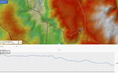
This can be used to plan new water infrastructure using FarmMap4D planning tools and profile tool. These planned infrastructure can then be exported to a GPS and checked in the field. You can see an example below where the red line on the map is a potential water pipe location, the graph indicates the profile of that line and allows the manager to consider if this is the bet line, what pumping equipment may be needed and accurately order pipe.

Planning already paying off
FarmMap4D has been taking the pain out of water infrastructure planning for over 5 years, saving its customers time and money by offering accurate online planning.
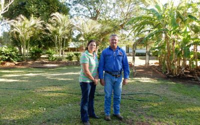
For Russell Lethbridge and family, FarmMap4D provides the pictures that are worth a thousand words.
The FarmMap4D technology ‘really comes into its own’ as a development tool, Russell says.
At Amber Station, managed by Russell and Donna’s daughter Georgia and husband Dan Slaney, the family measured grazeable areas and put circles around existing waters to assess what numbers of cattle they could sustainably run.
“Measurement on these big places can be a long way out, and the accuracy of FarmMap4D is critical when we’re outlaying money.”
The application of grazing ‘circles’ to ensure cattle don’t have to travel further than 2.5km to water, which leads to proper utilisation of available pasture, has been a cornerstone of the Lethbridges’ development of their properties.

“Measurement on these big places can be a long way out, and the accuracy of FarmMap4D is critical when we’re outlaying money.”
Are you planning new water infrastructure for your property? Or do you need to assess and record what you currently have on your property?
FarmMap4D can assist with both, gathering valuable data on your property and enabling smart decision making for future spend. Click here to find out more.
Also don’t forget to see if you can access funding. On 2 October 2020, the Australian Government announced an additional $50 million of funding for the expansion of the On-farm Emergency Water Infrastructure Rebate Scheme in 2020-21. This rebate is available for primary producers and horticulture farmers in all states and territories: https://www.agriculture.gov.au/water/national/on-farm-infrastructure-rebate.
Eligible expenses include:
- buying and installing
- pipes
- water storage devices such as tanks and troughs associated with stock watering
- water pumps and associated electronic systems to manage water delivery
- desilting dams
- drilling new stock water bores and associated power supply such as generators.
It is imperative that our producers and farmers make the most of this Scheme and use the rebate wisely, through information currently available for properties in Australia, with tools such as FarmMap4D.